


New York Subway Map by Dayou app for iPhone and iPad
Developer: Michael Sanderson
First release : 14 May 2013
App size: 19.5 Mb
Subway Map by Dayou is an app for the New York City subway that takes the iPhone on the subway to a new standard.
● Opens the subway map directly on launch.
● Allows maps to be zoomed to infinite detail and stay perfectly sharp.
● Includes 28 maps officially licensed from the MTA, including maps for the subway, Metro-North and Long island Rail Road, Buses, and neighborhoods (details below).
● Special display technology keeps file sizes down. Total app size: 20.5 MB.
● Works completely without an Internet connection.
● Bus maps for all five boroughs.
● Automatically switches to “Late Night” subway map from midnight to 6:30 a.m.
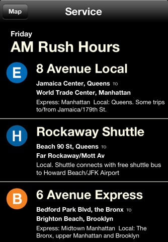
● Service guide displays what lines are running to what endpoints based on current day and time (including AM Rush, Midday, PM Rush, Evening, Weekend and Late Night).
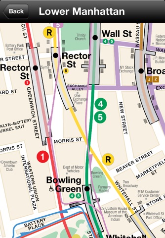
● Puts “Neighborhood Maps” in your pocket: These are the maps that hang in stations and include detailed street maps, landmarks, and station outlines with exits.
● Displays maps in unique "subway station" user interface that makes selecting the right map fast, intuitive and fun.
Inaugural edition without ads.
More maps and features coming soon.
Maps © Metropolitan Transportation Authority. Used with permission.
NOTE: This is early-release software. Some neighborhood maps have not been updated for changes in service. Dayou Unlimited, Ltd. and the MTA are not responsible for the results of any errors; when in doubt, please check with a station attendant or MTA employee or go to mta.info. Please leave feedback or get support at http://FreeSubwayMap.com.
PLEASE: Don’t forget to rate the app – we won’t bug you about it with annoying popups, but this does help us to show up in app search results. So if you like it please come back and rate us.